Mining in Manitoba
Geophysical Methods
Magnetic Surveys
|
|
Certain minerals distort the earth's field, and where sufficiently large concentrations of such minerals occur, variations can be measured by magnetometers mounted in aircraft, in ground vehicles, or positioned at stations on the ground. Magnetite iron ores have been found in many areas of the world using the airborne magnetometer.
In one case in the western United States, a very large iron deposit has recently been discovered beneath several hundred feet of barren volcanic flow rock erupted over the ore deposit. Magnetic copper skarn, magnetic nickel ore, and asbestos-bearing serpentine associated with certain magnetic intrusive rocks have been found, using the magnetometer. Some geophysicists propose the use of the magnetometer to detect gold placer deposits, because of their common association with black sands largely consisting of the mineral magnetite.
 |
Magnetometer surveys are rapid and efficient. Magnetometers can be used to detect buried ferrous metal objects (tanks or drums) or bedrock features with contrasting magnetite content. Detection depends on the amount of magnetic material present and its distance from the sensor. A single steel drum can be detected at burial depths up to 15 or 20 feet. Burial depth can be estimated from magnetometer data collected using the gradient method. |
Constraints: Utilities, power lines, buildings, and metallic debris can cause interference. Solar magnetic storms may cause fluctuations in readings. The size and depth of objects affect detectability.
Method: When a ferrous material is placed within a magnetic field such as the earth's, it develops an induced magnetic field. The induced field is superimposed on the earth's field at that location creating a magnetic anomaly.
A magnetometer survey for hydrogeologic and engineering applications is conducted on foot, by one operator. The survey can be along single lines or along a series of parallel traverses with readings taken every 5 to 50 feet. Spacing of traverses and readings depends on the width of the expected anomaly. For instance, tank searches may be conducted at a 5-foot spacing while geologic mapping may be conducted at a 50-foot spacing.
In the gradient method, the total field is measured simultaneously at two elevations by using two sensors on a staff separated by a fixed distance. The difference in magnetic intensity between the two sensors divided by the distance between them is the vertical gradient. This technique reduces interference from solar magnetic storms and regional magnetic changes. This technique is particularly useful for locating small, shallow objects and is also useful for estimating burial depth of objects.
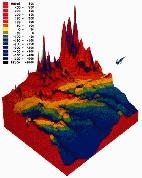
The results of magnetometer surveys are presented to the client in a full report that generally includes magnetic profiles, and an index map showing locations of magnetic anomalies. Magnetic contour maps and other graphic presentations are also available.