Mining in Manitoba
Geophysical Methods
Gravity Surveys
 |
Applications
|
Gravity methods depend upon the relative density of the ore deposit and surrounding wall rock, and are not much used in metalliferous exploration. Measurements can only be made at fixed stations on the ground, and complicated corrections are required for station position and topographic conditions. The typical ore deposit is not dense enough, is too small and irregular, and occurs in a deformed structural environment, making clearly defined gravity anomalies difficult to discern and interpret.
The method has been very successful in exploring for large deposits of petroleum, natural gas, sulfur, and salt. Limited application has been reported in exploration for barite.
Gravity surveys can provide useful information where other methods do not work. For example, gravity may be used to map bedrock topography under a landfill, where seismic refraction is limited. Gravity can also be used to map lateral lithologic changes, and faults.
Constraints: Gravity surveys are relatively slow and expensive. Detectability varies with target size, depth and density contrast. Interpretation of data often requires control data from drilling, outcrops, or other sources. Detailed surface topographic survey data is also required.
Method: Gravity is the attraction between masses. The strength of
this force is a result of the mass and distance separating the objects.
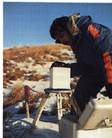
A gravimeter is used to measure the earth's gravitational attraction at various points over the area of interest. Gravity anomalies are due to differences in density of underlying materials. Gravity anomalies are extremely small relative to the total field and are usually measured in micro-Gals (one micro-Gal is about 1 billionth of the earth's total gravitational field). The equipment used in a gravity survey is extremely delicate and precise. Data interpretation is time consuming even with the use of sophisticated computer programs.
Results are presented in a full report which includes profiles or a contour map and gravity data tables.